


In the middle of a record-breaking heatwave with wildfires burning in several parts of the country, here’s how to find out where they are and the risk level where you live.
With soaring temperatures and little rainfall, Spain often suffers wildfires over the summer season.
This year’s fire season started early, however, with blazes in Castellón province forcing the evacuation of locals.
Nearby, the Catalonia government recently lifted a lockdown that confined 12,000 residents to their homes as firefighters managed to contain the blaze that broke out in La Bisbal d’Emporda, 12 miles from the popular Costa Brava coastline.
READ ALSO: Why Spain’s rainy spring is leading to more wildfires this summer
As of Thursday morning, there are still several active wildfires in Spain.
In Castilla-La Mancha firefighters were working to extinguish the forest fire that broke out on Wednesday afternoon in the Las Pinillas area, within the municipality of La Guardia (Toledo), which has already burnt some 500 hectares.
In Catalonia, the Generalitat’s fire service on Wednesday evening declared forest fires in Navarcles (Barcelona) and Guimerà (Lleida) to be under control.
From early Thursday morning, the regional fire service deployed 108 crews to tackle the six simultaneous fires burning in the region and declared them “under control”.
However, at around 11a.m on Thursday, Catalonia’s Civil Protection Agency issued a new Es-Alert for the village of Pla de Manlleu, in Aiguamúrcia (Tarragona), ordering residents to remain indoors due to a localised resurgence.
In Castile and León, fires in Ribota de Sajambre and Espina de Tremor improved this morning, Spanish media reports suggest, with only the latter still classified as top level severity.
There are also reports on Thursday morning of blazes in the Cádiz, Alicante and Córdoba areas.
Where are the wildfires in Spain?
These fires can be particularly scary if you live in the nearby areas or if you find yourself travelling through an area that has been ablaze or covered in dark smoke.
Thankfully, there are ways to find out where the active wildfires are, how intense they are, how big they are and the current status of each.
It’s worth noting also that many Spanish media outlets also post updated fire maps, such as this Europa Press map available here that allows you to search by municipality.
If you want to know about past fires, you can also look at this map from Civio which shows all the wildfires in Spain between 1968 and 2017 that burned one hectare or more.
Google Maps
Google combines public data with satellite imagery and automated models to provide wildfire information, which is frequently updated.
The Google Maps app is accessible from both iOS and Android. You can also find it on your desktop browser at maps.google.com. Here you’ll find a layer specifically dedicated to wildfires.
To find it, simply open Google Maps and tap the layers icon. On a computer, it’s located in the lower right corner. Once it appears it will shift to the left and you’ll click on ‘Layers’. From here, click on more and then on the ‘Wildfires’ icon.
On a mobile device, it appears on the home screen. From the menu, select ‘More’ or ‘Crisis Layers’. then activate the ‘Wildfires’ layer like before.
You need to zoom into a particular area to be able to see them.
READ ALSO: What to do and what to avoid if you see a wildfire in Spain
Once activated, the map shows real-time data such as satellite-detected hotspots, estimated fire perimeters, and impacted areas. SOS icons include emergency phone numbers, links to civil protection, and evacuation alerts.
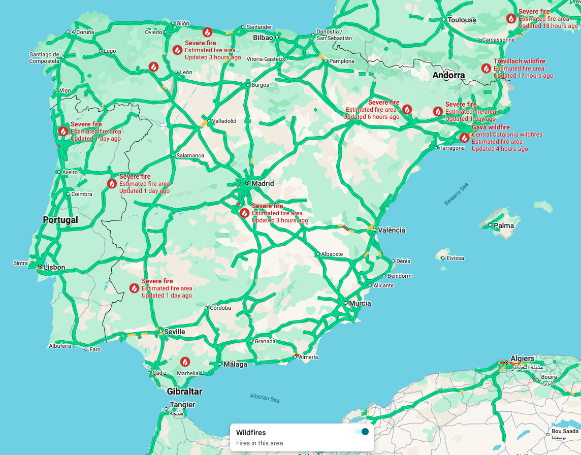
There are various active wildfires in Spain. Photo: Google Maps.
Incendios Forestales en España en Tiempo Real
The Incendios Forestales en España en Tiempo Real page uses various sources including NASA satellites and local fire emergency service information to track forest fires.
It combines data on active wildfires in Spain and automatically updates every 5 minutes.
The interactive map lets you search on a regional level and groups individual fires into single heat points, which are colour-coded by severity.
This map combines data on active wildfires in Spain from four complementary sources, which are automatically updated every 5 minutes.
As of 11:30 on Thursday morning, the map showed 213 different satellite points.
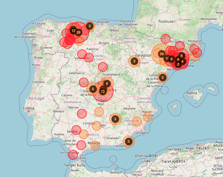
Photo: Incendios de España.
Wildfire alert levels
Similarly, for an overall picture of the risk level, Spain’s state weather agency, Aemet, provides maps, available here and below, that show danger levels for risk of forest fires and wildfires.
The forest fire weather danger level, which Aemet issues daily, is based on the FWI index from the Canadian system (calculated using data from Aemet’s weather stations and prediction model) combined with non-meteorological variables such as land and vegetation conditions, forest land use and soil moisture.
As per Aemet’s danger level system: “Fire danger is categorised into six classes or danger levels (very low, low, moderate, high, very high and extreme), which serve as indicators of the probability of a fire occurring, as well as its extent and intensity.”
On Thursday, large areas of eastern and southern Spain are on red-level (extreme risk) with lots of inland Spain on orange-level alert (very high).
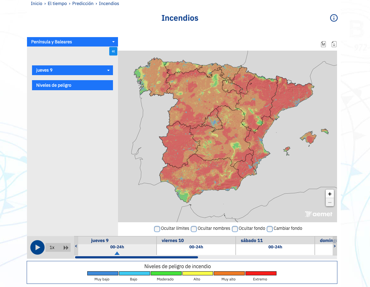
Wildfire risk levels. Photo: Aemet.


